What are photo book travel maps?
These maps are single page designs that you can insert into your photo book to showcase your travel destinations. They are fully customisable and feature a map base, locations, a travel path, titles and embellishments such as travel icons or flags. Please note, these maps are designed manually by one of our team members and take approximately 3-5 working days.

Meet our new editor!
Our new dedicated editor is here. Try out all the features before you make a purchase.
*Editor works best with Google Chrome
HOW IT WORKS?
Pick a style
Pick a map base style. Please note, the map base can not be changed after purchase.
Select photo book size
Select your photo book size and orientation. These can not be changed after purchase!
Fill in locations
Enter your locations and select any other options. Locations can not be changed, added or removed after purchase!
Submit order
Submit your order and make payment. Please note, for travel maps, payment is requested upfront since these are manually designed.
Wait for your map link
You will receive an email notification with your map link and username within 3-5 working days (sometimes sooner).
Edit your map
Edit your map: change text, add travel icons, add stories, add titles, add flags and add illustrations. Please watch our tutorial to learn more about the editor.
Request download
When you're finished editing, save your work and email us. You will receive an email with your high res map within 1 working day.
Browse Travel Map Styles
-
Photo Book Custom Travel Map | Terrain
Regular price From £9.99 GBPRegular priceUnit price per -
Photo Book Custom Travel Map | Classic
Regular price From £9.99 GBPRegular priceUnit price per -
Photo Book Custom Travel Map | Minimalist
Regular price From £9.99 GBPRegular priceUnit price per -
Photo Book Custom Travel Map | Watercolour
Regular price From £9.99 GBPRegular priceUnit price per -
Photo Book Custom Travel Map | Watercolour Texture
Regular price From £9.99 GBPRegular priceUnit price per -
Photo Book Custom Travel Map | Highlight
Regular price From £9.99 GBPRegular priceUnit price per -
Photo Book Custom Travel Map | Solo Country
Regular price From £9.99 GBPRegular priceUnit price per


-
What can you add to your map?
- Titles & Text
- Flags
- Travel Icons
- Landmark Illustration
- Photos
-
What can you NOT change?
The following parameters can NOT be changed after purchase:
- Location markers and Travel Paths
- Map colours (*water can changed in certain styles)
- Zoom the map
- Photo Book size and orientation
Long Distance Pop Up Maps
-
-
Extra Maps
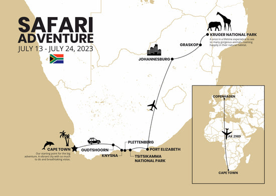
- It's hard to imagine how a map will look as the distance between the locations can make a map very crowded. For this reason, we separate long and short distance travel.
- If your starting (departure) point is very far from your main locations, that is the long distance leg of your journey. For example, if you travel from Copenhagen to South Africa, your locations in Africa will be very close to each other but the starting point (Copenhagen) will be very far.
- Showing all these on one map will make the Africa locations tiny and hardly visible. In this case, we will add a smaller pop up map that shows your long distance travel. You can also omit your starting point (Copenhagen) and have just your destinations (South Africa) on the map.

How To Create a Travel Map | Tutorial
